
Hiking In Alaska On A Cruise: 12 Best Trail Choices
Alaska cruises are all about enjoying the great outdoors and spectacular scenery. If you prefer to avoid expensive shore excursions, hiking in Alaska offers amazing views and allows you to connect with the environment.
Exploring the great outdoors provides views of cascading waterfalls, and a chance to enjoy the Tongass National Forest. You can book a guided hiking tour through your cruise line or explore the Alaskan wilderness yourself.
So, put on your trekking boots and explore southeast Alaska on these best hikes near the Alaska cruise ports.
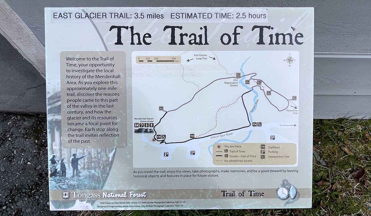
East Glacier Trail – Juneau
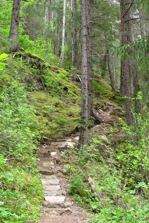
The East Glacier Looping Trail at Mendenhall Glacier Park provides more of a workout for avid hikers. The 3.1 mile or 5 km path includes stairs and steep inclines and takes the average hiker under two hours.
Wearing waterproof footwear will help keep your feet dry on the wet sections. Stemming from the Trail of Time, you can combine both routes for a 2-in-1 trek.
As a looping trail, you have the option to hike clockwise or counter-clockwise. It’s easier to go clockwise and walk up a steep incline and down the 194 stairs on the descent.
The forest canopy is quite beautiful and provides some shelter should it rain. While the lower section of the trail has dense vegetation, it thins as you get higher, offering elevated views of the lake and glacier.
In summer, the trail is popular amongst dog owners and small group tours who provide guided hiking tours of the East Glacier Trail.
Alternatively, if you want to walk on the glacier, you can take a guided Mendenhall Glacier Ice Tour, which includes a canoe and trek on the icefield.
Nugget Falls – Juneau
You’ll have diverse options of excursions in Juneau, on your Alaskan cruise. If you decide to hike in the capital city, Juneau offers multiple options.
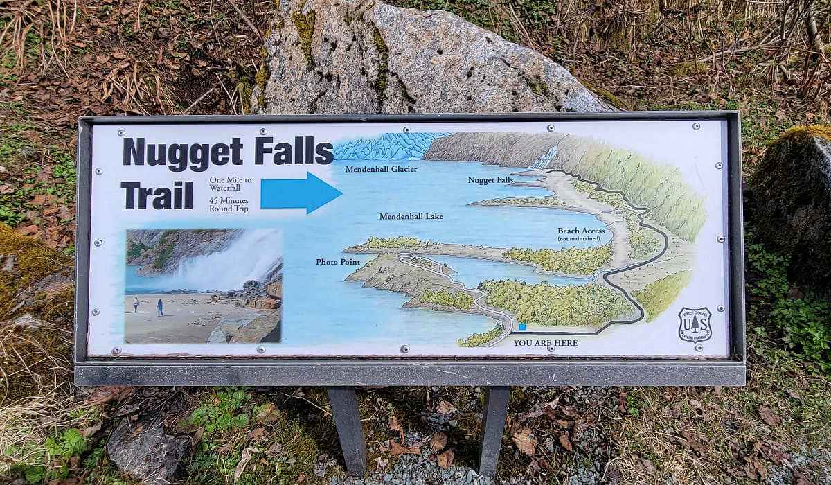
By heading to Mendenhall Glacier, you can choose from the Trail of Time, East Glacier Trail, and Nugget Falls. To reach the park, take the Blue Bus Glacier Express which provides roundtrip transportation, and time to explore at your leisure.
Nugget Falls Trail provides an easy hike for those who want a less strenuous trail. In under one mile, you’ll enjoy a closer look at the Mendenhall Glacier, although the mountain obscures the glacier’s terminus.
Start at the visitor center, hike towards the ice field, and take the right-hand route when you reach the fork. The trail is relatively flat, well-maintained, and surrounded by lichens, spruce seedlings, and fireweed.
Since there’s no actual elevation gain, you can walk this trail with everyday runners. Along the path, you can see signs of where the glacier pulled rocks over the bedrock. As Mendenhall’s most popular hike, expect to share the route with many others at busy times.
You’ll reach a sandy bar at the end of the trail to enjoy the thundering Nugget Falls. You may see salmon making their way up the creeks if you hike during salmon season.

On your way back, stop at the Photo Point Lookout for better views of Mendenhall Glacier. Since this trail gets very busy in summer, plan to arrive early to avoid the crowd.
Trail Of Time – Juneau
Also in Mendenhall Glacier Park, the Trail of Time provides another good option and can be combined with the Nugget Falls Trail. This 1.1-mile (1.8 km) interpretive trail documents the retreat of the nearby icefield.
Walking the Trail of Time allows you to step back in history and see the glacier’s recession by noticing markers (1916, 1920, 1936, and 1937) along the route. At the beginning of the trail near the visitor center, a board displays some historical pictures.
Since bears are often spotted on the trail, visitors should only carry water and avoid flavored drinks and snacks when hiking.
The trail crosses Steep Creek, and it’s an opportunity to see spawning salmon in summer. You might see one of the resident porcupines high up in the trees.
Allow up to 25 minutes to complete this easy Juneau hike.
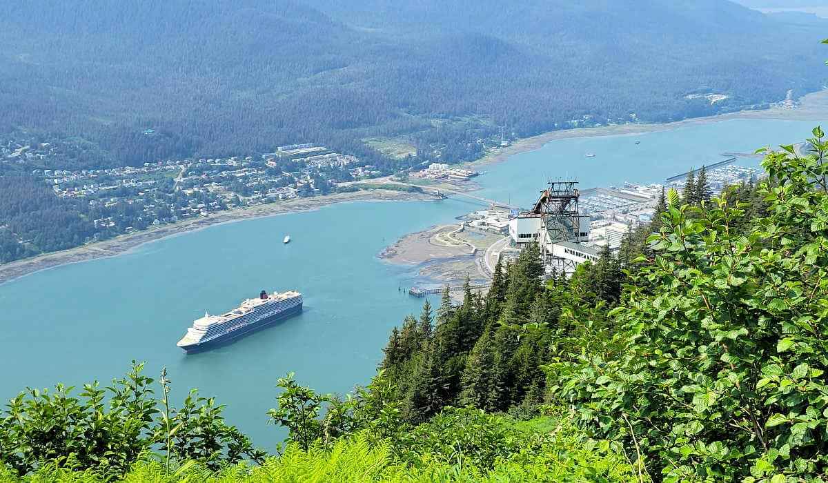
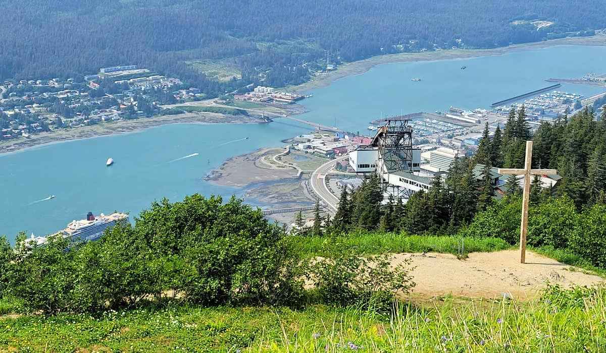
Mount Roberts – Juneau
As you can see, Juneau is one of the best Alaska cruise ports for hiking. While Mendenhall Glacier Parks offers some of the best hikes, consider taking the Mount Roberts Tramway for additional routes.
From the top of the tram, you can enjoy spectacular views of the Gastineau Channel and downtown Juneau. While you can hike from town to the peak, the trail is lengthy and often quite muddy. So, take the Mount Roberts tram and begin your hike at the top.
The tram departs in front of the cruise ships and offers excellent views on the way up. Exiting the tram, you have several options for hiking.
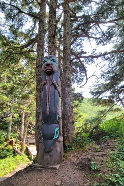
The Alpine Looping Trail takes 30 minutes from the Mountain House to complete a 0.5-mile route. It meanders through trees and open areas and has lovely carved poles and native artwork. This trail connects to the main one, which goes to Gastineau Peak.
The more popular route travels to Father Brown’s Cross. This 1-mile trail takes up to an hour and has an elevation gain of 300 feet.
Built in 1908, a large cross was erected at the peak, and the trail was named after the catholic priest who assembled a group to create the trail.
For avid hikers, the trail continues to Gold Ridge or Gastineau Peak. The latter is more challenging, with almost a 2,000 feet elevation gain. Expect to take about 4.5 hours to complete the roundtrip hike.
Rated at intermediate, the 3-mile roundtrip Gold Ridge Trail takes up to three hours and has an elevation gain of 1,500 feet. With fewer people on the higher elevations, you can see mountain goats, Sitka Black-Tailed Deer, and black bears.
Gold Creek Flume – Juneau
As you can see, Juneau, the capital, has many hiking options. The Gold Creek Flume trail is an easy one with an interesting history. In 1893, Willis Thorpe installed an electric generator and water wheel on Gold Creek.
While the initial hydroelectric installation has been modernized, the plume still remains. Expect to take 35 minutes to complete this 1.4-mile (2.3 km) roundtrip hike.

The out-and-back trail consists of a walking surface made from pressure-treated lumber. Due to the ease of this route, we met many locals with their four-footed friends.
Cottonwood, alder, hemlock, and spruce trees line the trail. During the summer, you could see black bears and porcupines.
Rainbird Trail – Ketchikan
[UPDATE] This trail is currently closed due to a landslide.
Located near the cruise port, the Rainbird Trail offers hikers a one-way or out-and-back circuit. The trail starts behind the University of Alaska and goes southwards, ending on Third Street.
Take the city bus or taxi to reach the trailhead. By doing so, the one-way route, which is 1.3 miles in length takes over an hour. Walking to the University and completing the circuit takes 2.5 hours. Either way, it’s a fantastic activity near the port.
The city doesn’t maintain Rainbird Trail. We experienced experience gravel at the start, which turned into steps, roots, and a narrow route through the rainforest. To prepare for rain and a muddy trail, carry a rain jacket and wear boots with ankle supports.
So, if you’re walking for the views, you have the option to do half the hike and return downtown by a set of stairs. From here, it’s a 30-minute walk to the cruise port on city streets. However, you’ll benefit from the all-downhill route.
Lower Dewey Lake – Skagway
While Skagway has an Upper and Lower Dewey Lake, we tackled the latter due to limited time in port.

The 3-mile (4.8 km) trail takes up to two hours to complete the circuit around the lake. However, you have the option to walk to the lake and back, which is one mile along a wooded hillside.
Rated as a moderate hike, the beginning climb has an elevation gain of 500 feet. The switchback trail starts off 2nd and Broadway near the cruise port and offers lovely views of Skagway on the ascent. We definitely felt the calf burn and met some people who gave up on the climb.
The trail passes a reservoir before reaching the lake loop. Bring a picnic lunch and enjoy it by the lake if you have nothing else planned for your day in port.
The right side follows the lake and the route is relatively flat. The left side has some ups and downs and meanders amongst the trees. We did the counter-clockwise route which had lesser climbs than the clockwise option.
Smuggler’s Cove – Skagway

Alaska hiking isn’t just for the fitness fanatics. There are some that are family-friendly.
If you want to avoid a busy activity in Skagway, a hike to Smuggler’s Cove (or Yakutania Point) provides a peaceful escape. From the Skagway cruise port, walk towards town and turn left on 1st Street.
Go past the airport and cross the Skagway River on a footbridge. Then turn left, follow the trail to Yakutania Point, and onto Smuggler’s Cove. The 1.4-mile or 2.3 km out-and-back trail provides a relatively flat route with little elevation gain, making it an ideal family activity in Skagway.
The path to Yakutania Point is wide and offers great views back to the cruise ships in port and out to Lynn Canal. Beyond, the trail narrows to Smuggler’s Cove.
Since this trail follows the coastline, look out for marine life. You could see seals, sea lions, and humpback whales.
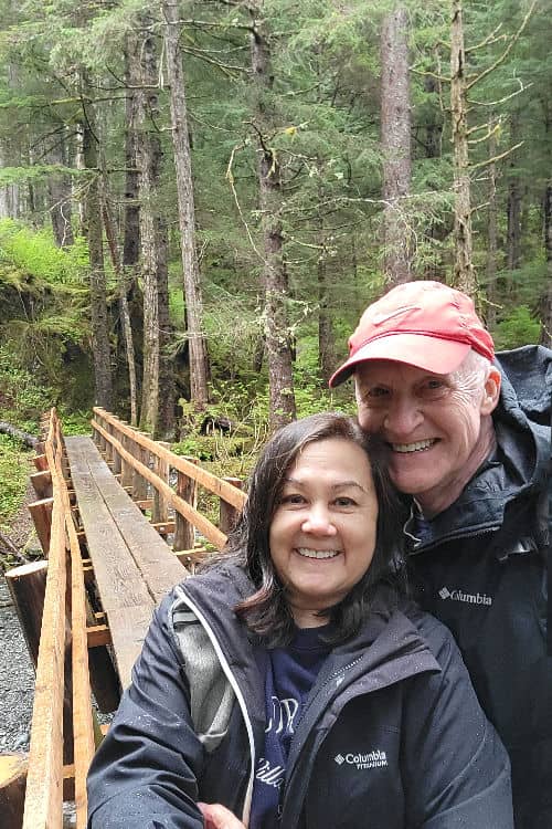
Chilkoot Trail – Skagway
Hiking any section of the Chilkoot Trail allows you to walk in the footsteps of the klondike prospectors many years ago. While the Chilkoot Trail is 33 miles, you can do an out-and-back section of the trail.
Alternatively, you can join a group tour to do a hike and float. This excursion combines a portion of the trail with a leisurely float on the Taiya River.
The trailhead starts in Dyea, a short drive from Skagway. To prepare for this hike, bring mosquito repellent, as the pesky bugs can be rampant in summer.
Hiking this Skagway trail isn’t just an adventure but a truly wild experience. The hike takes you through the shady Tongass National Forest, filled with moss and lichen. The initial section requires careful footing as roots and rocks become a tripping hazard.
Should you do the hike with a local tour company, the guide will point out bear claw marks on a tree.
Herring Cove Trail – Sitka
If you’re into waterfall chasing, this hike is truly magical. The Herring Cove Trail takes just over two hours to complete the 3.6-mile or 5.8 km looping trail.
The first part of the trail provides a bit of a stair climber workout. However, the babbling streams, scenic views, and picture-perfect trail will reward you for your efforts.
The Forest Service keeps the path well-maintained. While relatively short, you’ll follow a stream and savor multiple waterfalls in a temperate rainforest.
You’ll experience a little of everything from narrow bridges and muskeg to rugged mountain views and maybe some wildlife.
The Sawmill Creek Road provides access to the trailhead. This moderate hike takes you around Beaver Lake before returning on the same trail.
Exit Glacier Overlook Trail – Seward
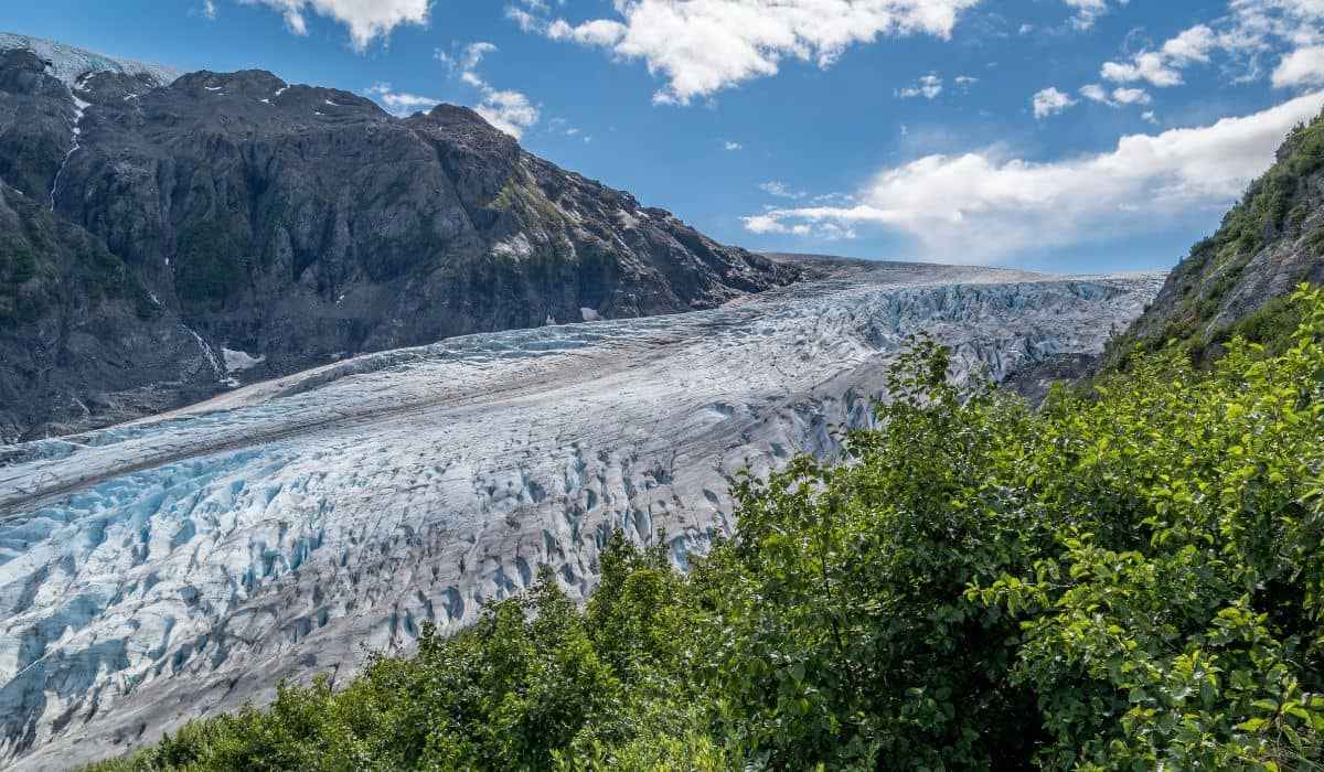
If you’re starting or ending your Alaska cruise in Seward, consider the Exit Glacier Overlook Trail. The hike is a 2.2-mile (3.5-km) loop trail, perfect for hiking and walking.
At an average of just under an hour to complete, it’s considered an easy route for hikers. However, be prepared for a steeper ascent near the peak, where you’ll be able to grab a glimpse of the glacier up close.
Don’t forget to bring bug spray and dress in layers, as bugs can be fierce and temperatures cool once you get close to the glacier.
Access the trailhead by taking Nature Center Access Road past the Exit Glacier Campground. During your hike, take note of signs with years, documenting where the edge of the glacier used to be. It’s a sad sign of climate change which causes glacial retreat.
Flattop Mountain – Anchorage

Located 30 minutes from Anchorage, Flattop Mountain offers one of the best hiking trails in Alaska.
If you’re planning a cruise and land tour to Denali National Park, your time in Anchorage allows you the opportunity to do this next hike. In fact, it’s one of the most popular things to do in Anchorage.
Hiking in Alaska doesn’t get any better than tackling Flattop Mountain. Boasting incredible views even before you reach the trailhead, this trail to the peak suits hikers with a superior fitness level. Expect to spend about 2-1/2 hours making the 3-mile or 5.3-km hike.
The Flattop Mountain Shuttle provides access to the trailhead if you don’t have a rental vehicle. If scaling this mountain is beyond your hiking ability, there are easier hiking routes near the base.
Blueberry Loop offers beautiful scenery and staircases made from railroad ties and is perfect for novice hikers. Those who take on the summit challenge should be prepared for the 1,500-foot elevation gain.
You may need to use your hands to aid in rock scrambling near the peak, but the views are worth the rigorous climb.
