
Best Hikes In Jasper National Park: 12 Easy Options
The Canadian Rockies have some of the finest panoramas globally. North of Banff, Jasper National Park sees fewer visitors, and it’s a great place to put on hiking shoes and immerse yourself in the landscape. So, if you’re looking for some great hikes in Jasper, we’re sharing 12 great options.
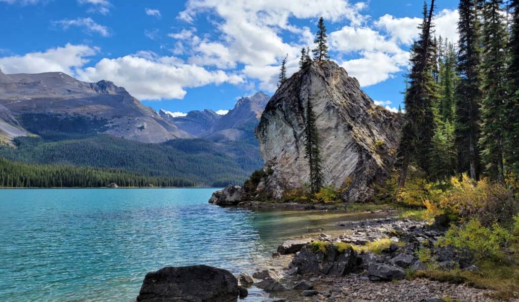
Jasper’s rugged peaks, turquoise lakes, and rushing waterfalls are jaw-dropping. While the endless landscape has an abundance of hiking trails suited for all fitness levels, these Jasper day hikes and walks are rated easy to moderate.
Established in 1907, Jasper is the largest national park in the Canadian Rockies and provides a similar caliber of scenery to Banff.
Unlike its southern neighbor, Jasper’s highways are unfenced, making animal viewings more common. So, as you explore the alpine meadows and rocky pathways, be on the lookout for wildlife, wildflowers, and feathered friends.
Where To Stay In Jasper National Park
Camping provides an inexpensive option when visiting Jasper in the summer. Jasper campgrounds are plentiful, with Whistlers and Wapiti campgrounds providing the lion’s share of the sites.
Near the Jasper townsite, the Fairmont Jasper Park Lodge has luxury accommodations surrounded by pristine landscapes and a wonderful golf course.
If you want something more budget-friendly, the Mount Robson Inn has a complimentary breakfast. Their rooms have mini-fridges and microwaves too. Alternatively, the Marmot Lodge offers a quiet location, with a Starbucks and a great restaurant on the property.

Located 6 km from the town of Jasper, the Pyramid Lake Resort offers a chalet-style venue with spectacular mountain views. Open year-round, you can enjoy hiking and canoeing in summer, and snowshoeing, fat biking, and cross-country skiing in winter.
So, if you have a few days in Jasper National Park, check out these easy to moderate hiking trails.
Athabasca Glacier
- Difficulty: Easy | Distance: 1.4 km loop
The Athabasca Glacier, part of the Columbia Icefields, is one of North America’s most accessible Glaciers by vehicle. It’s the ideal halfway stopping point on the Jasper from Banff drive.
I first visited the Icefields in 1983 when the glacier was near the parking lot and accessible on foot. Today, it has retreated significantly, melting up to seven meters a year. Due to the large lake beneath its face, visitors can no longer walk on the ice.

From Icefields Parkway, take the exit west of the Columbia Icefield Discovery Centre and drive to the parking lot. Dress warmly because we experienced a frigid wind off the glacier.
Cross a wooden bridge and follow the rocky path. Though not a formal trail, it climbs 61 meters in about an hour, growing longer as the ice retreats. Markers show the glacier’s past positions, highlighting its rapid decline.
A large river at the terminus blocks access to the ice. Stay within the roped area for safety, then follow the loop back to the parking lot. For those who want to forego the pricey Pursuit bus excursion, the hike to the glacier provides a great alternative and a fantastic way to explore part of the Columbia Icefields.

Wilcox Pass
- Difficulty: Moderate | Distance: 9 km return
Named after Walter Wilcox, the first explorer to walk these lands, Wilcox Pass offers one of the best hikes for Columbia Icefields views without walking on it. I camped at the Wilcox Creek campground (3 km south of the Icefields) to gain early hiking access.
This unserviced Jasper campground has 46 sites and easy access to the Columbia Icefields. I woke to July snow, and the trail was freezing.
The hike starts steeply through old-growth spruce, challenging at over 2,000 meters, where thin air makes breathing harder. With a 500-meter climb, pace yourself. After 1 km, we were rewarded with a rest at the Parks Canada’s iconic red Adirondack chairs and amazing Sunwapta Pass views.

Beyond the treeline, icy winds will chill you to the bone if you haven’t dressed appropriately. At Wilcox Pass, the views of Mount Athabasca and Snow Dome are stunning. Watch for Bighorn sheep, golden eagles, and grizzlies. Thankfully, the return is all downhill.
Upper Moose Lake
- Difficulty: Moderate | Distance: 3.5 km loop
In the winter, visitors use the Moose Lake trail for cross-country skiing. However, the Jasper day hike offers a chance to see moose grazing in the marsh near Maligne Lake in the summertime.
Drive to Maligne Lake, pass the first parking area and buildings, and park in the second lot to access the trail. Here, look for the sign for the Moose Lake Loop trail close to the bathrooms.
Walking parallel to Maligne Lake, the trail passes a boat launch and continues hugging the lake’s edge. Five hundred yards in, it reaches a junction where the trail turns into a loop.

We hiked the loop counterclockwise, reaching Moose Lake 700 meters in. The maintained trail was wide and easy, but we saw no moose. Those wanting a shorter walk can return the same way.
Beyond Moose Lake, the unmaintained path narrows, becoming muddy and overgrown with moss and mushrooms. I was amazed to find a massive ‘Scaly Hedgehog’ mushroom larger than my boots.

The trail meets Maligne Lake, following its root-covered shoreline. Though flat, it was tricky to walk, and September’s mosquitoes kept us moving. Along the way, we spotted a cow moose and her calf swimming across the lake.
Valley Of The Five Lakes
- Difficulty: Moderate | Distance: 4.6 km loop
Unlike Banff’s glacier-fed lakes, the Valley of the Five Lakes features small tarns with vibrant turquoise and aquamarine hues. Each lake gets its vivid color from rock flour and algae.
This easy loop trail has some elevation changes. Hike clockwise to see lakes one through five or counterclockwise. The route passes between lakes one and two, follows the third, then winds between lakes four and five on the return.

On hot days, we suggest bringing a swimsuit as the ponds are warmer than glacier-fed lakes. A longer trail circles the first lake, passing beaver dams and wildlife like deer, elk, coyotes, and black bears.
Expect moderate summer crowds. While the second lake is less impressive, lakes three through five dazzle with clear water and vivid reflections. A set of red Adirondack chairs near one lake invites a perfect selfie.
Stanley Falls
- Difficulty: Easy | Distance: 3.2 km return
For a scenic waterfall hike in Jasper, Stanley Falls is a must. The toughest part was finding the small parking lot 2 km south of Beauty Creek Hostel.
I first hiked this hidden gem in the 1990s. Though still relatively unknown, it’s a great alternative to Banff’s crowded Johnston Canyon.

The trail crosses Beauty Flats, turns onto an old road, and follows Beauty Creek past ten picturesque waterfalls. The unmarked path leads to the gorgeous Stanley Falls, but with no guardrails or signs, caution is needed.
This is bear country with few hikers, so don’t go alone. Make noise, stay alert, carry bear spray and know how to use it. With its beauty, I wonder if Beauty Creek will remain a secret. Enjoy Stanley Falls before it’s discovered.
Path Of The Glacier Trail
- Difficulty: Easy | Distance: 1.6 km loop
I felt a connection to Edith Cavell on my first visit, and it still astounds me today. Less visited than its more famous attractions to the south, Edith Cavell offers a chance for solitude. On a clear day, its 3,353 meter peak is visible from Jasper town.
Named after a British nurse who helped hundreds of soldiers escape during World War I, she was executed for her crimes. Later, her body was interned at England’s Norwich Cathedral.

The narrow, switchback road to the parking lot isn’t RV-friendly. In fact, it’s difficult to negotiate in a regular sized vehicle. Drive slowly and enjoy the mountain views.
From the lot, a paved path climbs the moraine, crosses a stream, and turns rocky. Each step reveals better views of the glacier and Cavell Pond. Above, Angel Glacier, named for its shape, has retreated significantly, losing its angelic form. Listen for thunder as ice calves into the mint-green water below.
In 2012, 70% of Ghost Glacier collapsed, flooding the valley and destroying trails. Today, a roped-off area keeps visitors from the pond in case of another collapse.
Edith Cavell Meadows
- Difficulty: Moderate | Distance: 8.4 km loop
The Cavell Meadows hike offers a stunning view of Angel Glacier for those who want more of Edith Cavell. With a 600-meter elevation gain, you don’t need to complete the loop to enjoy the breathtaking scenery.

Starting on the Path of the Glacier trail, it soon veers off, climbing steeply over rocky moraine. Along the way, watch for pika and sunbathing hoary marmots.
The trail passes through subalpine fir and spruce before opening into wildflower-filled meadows in July and August. Look back as you climb as the glacier and mountain views are spectacular.
Near the top, a steep loop begins; skip it if it’s too challenging. Snow may cover the path early and late in the season, so bring crampons and poles. While dogs are allowed on many Canadian Rockies trails, they are forbidden on this one as it’s a caribou habitat.
Maligne Canyon
- Difficulty: Moderate | Distance: 6.8 km loop
Maligne Canyon, Jasper’s most accessible canyon, offers multiple hiking options with three parking lots. Hike from bridges one to six or start uphill for a more challenging ascent. From the Maligne Canyon Wilderness Kitchen lot, additional routes are available.
| Bridges 1 and 2 | Easiest hike | Takes 20 mins |
| Bridges 1 thru 3 | Easy hike | Takes 40 mins |
| Bridges 1 thru 4 | Slightly harder hike | Takes 1 hour |
| Bridges 1 thru 5 (can also hike 5 thru 1) | Harder hike | Takes up to 2 hours |
| Bridges 1 thru 6 ( can also hike 6 thru 1) | Hardest hike | Takes up to 3 hours |
Those wanting to see all six bridges without hiking the 6.8 km trail can hike from bridges 1 to 4 and drive to see the other two bridges. The more manageable sections are heavily trafficked, but the crowds dissipate as you walk further.
We hiked from the deepest part of the canyon downwards. Maybe not the smartest option since we had the uphill section at the end of our trek.

At times, we couldn’t see the water but heard it raging below. Maligne Canyon’s karst system, formed by dissolving limestone and dolomite, features caves, sinkholes, and underground springs.
This hike includes waterfalls, with the first bridge showcasing one. The second bridge offers the deepest view, 51 meters down, with a chockstone wedged near the top.
The fenced trail has paved and dirt sections. At the third bridge, the river widens, revealing rock potholes. Past the fourth bridge, underground water from Medicine Lake feeds the river. The trek to the fifth bridge felt long, with some muddy sections.

The new suspension bridge at the fifth crossing spans the widened Maligne River. It leads to a picnic area, outhouses, and the lower parking lot, perfect for a break.
Between the fifth and sixth bridges, the trail passes underground waterways through a fir forest. We returned via a quieter, more direct uphill meadow path at the fifth bridge fork.
Ending at the upper lot? Reward yourself with a meal at Maligne Canyon Wilderness Kitchen, one of the top restaurants in Jasper.
Old Fort Point
- Difficulty: Moderate | Distance: 3.7 km loop
For aerial views of Athabasca Valley, hike the Old Fort Point Trail near Jasper town. This popular, dog-friendly loop gets your heart racing. The trail starts near the Old Iron Bridge which traverses the Athabasca River.

Hike clockwise for a steep descent at the end or counterclockwise for a direct ascent to the viewpoint. Some skip the full loop, hiking counterclockwise just for the views.
Clockwise, the trail begins with an easy pine forest stroll before a steep climb. It then loops back, revealing stunning panoramas of the Miette and Athabasca Valleys. Watch for Bighorn sheep and grizzlies along the way.
After enjoying the summit, we found the descent tricky due to loose rocks and gravel. Once past the wooden stairs, the trail flattens for an easy finish.
Athabasca Falls
- Difficulty: Easy | Distance: 1 km
While not a hike but a walk around a roadside attraction, Athabasca Falls should not be missed when visiting Jasper National Park. At almost 50 meters wide, the memorable waterfall captivates travelers with its thunderous volume of water falling into a gorge.
Depending on when you visit, the water can vary in color. During my last trip, the water was pale green, created from the fine silt from melting glaciers. Another time, I witnessed the falls roaring a muddy torrent.

The water in the Athabasca River originates from the Columbia Icefields. From the falls, it continues on a 6200 km journey to Great Slave Lake and Mackenzie River before flowing into the Arctic Ocean.
At Athabasca Falls, there are plenty of photo opportunities from the bridge and numerous viewpoints on both sides of the river. Be sure to walk down the stairs through an ancient canyon where the water once flowed.
At the bottom of the stairs and to your left, visitors can view a giant pothole created by the water. Following another staircase down, you’ll arrive at the river’s edge, now wide and no longer in rage mode.

Every few years, someone dies at the falls when they venture past the safety fencing in an attempt to capture a better picture. As the sign at the falls says, “step off the trail, and you risk your life.” Don’t be that person.
Lake Annette Loop
- Difficulty: Easy | Distance: 2.7 km
Hike the scenic Lake Annette loop in Jasper, a kettle lake fed by underground water from Medicine Lake. Unlike glacier-fed lakes, its warmer blue-green waters are perfect for summer swimming.
This paved, well-marked trail is ideal for all skill levels, with mountain displays along the route. Though wheelchair-accessible, one hill may be challenging.
The trail offers beautiful views, a glimpse of glacial lakes, and an introduction to local rock formations.

Beauvert Lake Loop Trail
- Difficulty: Easy | Distance: 5.3 km
If you’re at Fairmont Jasper Park Lodge, the 5.3 km Beauvert Lake loop is a must! Start at Old Fort Pt Road and hike counterclockwise. After 300 meters in the woods, you’ll reach the shoreline for stunning views of Pyramid Mountain and the lodge. Follow the lake’s horseshoe shape south to complete the loop.
Flat and easy, this trail offers a fresh perspective of the turquoise lake. Without a car, it’s a perfect choice. Expect elk sightings and loon calls along the way. In May, sections may close for elk calving, and we suggest avoiding mothers with calves, as they can be aggressive.
Jasper Hiking Tips
Any time you venture out on a trail, you’re in bear country. Exercise caution by not traveling alone, having a bear bell or making noise, and carrying bear spray that’s easily accessible. Bring plenty of water and protein snacks in a waterproof backpack.
- Check on the forecast before heading out and dress for the weather conditions.
- The use of hiking poles saves your knees on some trails.
- Take out what you took in.
- Wear good hiking boots with wool hiking socks.
- Check on the condition of the trail first.
- Don’t wander off the trail.
- Don’t remove plants, fossils, or rocks.
- Hike in a group if it’s required.
- Don’t take your dog on a trail where dogs are not allowed.
Final Thoughts
Banff and Jasper are similar, but Jasper sees fewer visitors, perhaps due to its northern location or lack of famous lakes like Louise and Moraine.
This means less traffic, quieter trails, and best of all, great wildlife viewing. We saw more animals in our first day in Jasper than our entire time in Banff. Jasper is a year-round destination; while some areas close to vehicles, many trails remain accessible with snowshoes or crampons.
For hiking enthusiasts, Jasper has over 1,200 kilometers of hiking trails. While the ones listed above are easier and shorter, hiking enthusiasts can enjoy longer, more challenging overnight treks.
