
14 Best Hikes In Banff You Need To Try
Stretching 4,800 km (3,000 miles) through the US and Canada, the Rocky Mountain Range draws visitors to admire its natural beauty. Banff National Park offers over 1,500 km (990 miles) of hiking trails. While there are many challending treks, we’re covering the best hikes in Banff with a rating of easy to moderate.
So, matter your hiking ability, there’s a trail for you. Choose from simple jaunts like the Johnson Lake loop, Peyto Lake lookout, and a Bow Riverwalk to challenging Cory Pass and Paradise Valley treks.
Some lakeshore trails are stroller-friendly, and most Banff hiking trails are dog-friendly as long as they’re on a leash.

Living in British Columbia, traveling to Banff National Park is an easy day’s drive. I’ve spent many summers camping in Jasper and Banff, searching for wildlife, enjoying the picturesque vistas, and savoring the outdoors on day hikes.
While I’ve always camped in the parks, I recently took a Vancouver to Banff road trip, this time staying in hotels. During my trips, I have done most of the easy-to-moderate trails, some of which required a whole day. I haven’t tackled any of the difficult or overnight hikes.
You always want to follow safety guidelines and practical hiking tips in the wilderness.
Parker Ridge
- Difficulty: Moderate | Distance: 2.4 km one way
I still remember having to get up at 5 am when it was damp and cold. Stumbling around in the dark, I knew the best time to tackle Parker Ridge was before the sun had risen.
While the trail is heavily trafficked during the summer, beating the crowd would allow for a leisurely climb, and I could savor the sunrise from the top.
The trail begins south of the Athabasca Glacier Visitors Centre, just south of Jasper National Park. The Parker Ridge trail starts in a wooded area with a series of switchbacks. It has an elevation gain of 270 meters.

While not as grueling as the Grouse Grind in Vancouver, the trail is best hiked slowly and steadily. Don’t be discouraged by the climb because the rewards for this strenuous hike are breathtaking.
Near the top, the vegetation becomes relatively sparse as the harsh winter conditions make it difficult for plants to thrive. So, tread carefully to prevent damaging the fragile alpine foliage.
Reaching the ridge, I was thankful to have a light jacket since the winds had picked up. Looking down into the valley, I was captivated by the unreal vistas.
To the right, Saskatchewan Glacier’s views were terrific, and I later took the long hike to the toe of this glacier. I spotted a group of mountain goats along the ridge with an inexpensive pair of binoculars.
Being the first to the top of the ridge, my reward for the climb was seeing the goats and a thermos of hot coffee. After enjoying the views and sipping a hot cup of coffee, I headed down to meet some hikers heading up.
Mistaya Canyon
- Difficulty: Easy | Distance: 1.8 km loop
Mistaya Canyon may not be as popular as Johnston Canyon, but its picturesque views are worth the trek. Unlike most hikes which start with an uphill ascent, this one descends into the forest.
Being shorter than most Banff hikes, the trail suits those with little or no hiking experience. After a short 10-minute hike, the trail arrives at a wooden bridge crossing the river.
From here, views of Mistaya Canyon are visible. It’s interesting to see how the force of water has carved out the rock and created potholes for the swirling waters.

Walking up and down the river provides different canyon views and multiple waterfalls cascading over the smooth rocks. In the distance, Mt. Sarbach provides a prominent backdrop.
Be cautious when hiking in the wet season because the rocks are slippery. Unlike Athabasca Falls and Maligne Canyon, this one has no safety railings along the canyon.
Saskatchewan Glacier
- Difficulty: Easy to moderate | Distance: 17 km round trip
Having completed the Parker’s Ridge Trail and seen the picturesque views of Saskatchewan Glacier, I wanted to reach the icefield’s terminus. While much longer than Parker’s Ridge at 17 km round trip, the hike has little elevation gain.
Due to its length and not wanting to hike in the dark, I planned this hike early in the day. The Saskatchewan Glacier trail starts at “Big Bend” and travels on an old gravel road until it reaches the trees.
There’s a series of switchbacks in the forest before the descent to the valley. It’s important to note that the trail is not well-traveled. In fact, I only saw one other hiking group during the day.

On the ascent through the forest, I came across fresh bear tracks, which reminded me I was in bear country. Arriving in the valley, I continued the hike along the river to the lake.
Approaching the glacier, I found the path quite rocky, so collapsible hiking poles to steady yourself are advisable. As I looked at Saskatchewan Glacier in the distance, it seemed close but took forever to get there.
Getting close to the terminus, I noted the pebbles turned into larger rocks, requiring some careful footing to navigate. For this reason, it’s best to have footwear with good ankle support.
Alongside the river, previous hikers had created cairns from the riverbed rock. Within the rocks, I found a large area of shale with numerous trilobite fossils.
They were fascinating and a reminder of the age of this land. If seeking some solitude away from the crowds, the Saskatchewan Glacier hike is one of Banff’s best bets.
Lake Agnes And Little Beehive
- Difficulty: Moderate | Distance: 7.2 km loop
While Lake Louise is a must-visit lake in Banff National Park, Lake Agnes attracts many visitors for its quaint tea house. If you plan to make this hike, remember to bring cash so you can reward your climb with hot tea and pastry at the edge of Lake Agnes.

Hikers have many hiking options from Lake Louise. These include the moderate hikes of Lake Annette, Larch Valley, and Eiffel Lake. Sentinel Pass and Fairview Mountain are considered more demanding hikes.
The Lake Agnes trail starts at Lake Louise Chateau. Follow the path to the right of the lake and look for the posted signs. During the summer, the people hiking this trail is comparable to rush hour traffic in Los Angeles.
With an elevation gain of 400 meters, expect to get out of breath at this high altitude. Initially, there are no views on the first section of the trail. Once you reach a higher level, you can enjoy views of Lake Louise.
At 2.6 km, the path stops at Mirror Lake, and beyond that, there’s an option to go left for Lake Agnes or right for the Little Beehive. I chose to visit the Little Beehive first and backtrack to the tea house afterward.

Arriving at the tea house, it’s a bustling place and rivals any Starbucks for business on a summer’s day. While the selections are pricy, bear in mind the ingredients for your lunch were supplied by pack horses who make this journey twice a week.
Big Beehive
- Difficulty: Moderate | Distance: 10 km loop
Some hikers choose to do the Lake Agnes tea house and both beehives in one hike, as I did. Others prefer to bypass the Big Beehive due to its extra length and strenuous climb. Therefore, this 10 km trail includes all three places.
Expect to spend four to five hours on this trail, depending on your fitness level and the number of times you stop for photos.
Like the previous trail, it starts at the Chateau, but instead of taking the route to the teahouse, I went left, following the path to the Plain of the Six Glaciers.

While this is a longer route, I preferred a looping trail to a path that doubled back on the same route. Also, the elevation gain stretched out gradually instead of steep inclines.
The turnoff to the Big Beehive is marked and turns to the right. It soon becomes a grueling switchback that is not for the faint of heart.
At the top of the Beehive, the views are beyond spectacular. Not only could I see Lake Agnes, but the headwaters to Lake Louise and the Chateau too.
From here, head back down the switchbacks and turned right for the loopback to Lake Agnes and the little Beehive.
If you’re relatively fit, I recommend the Big Beehive in addition to the previous hike because the views are unforgettable.
Plain Of The Six Glaciers
- Difficulty: Moderate | Distance: 14 km round trip
One of the most accessible hikes in Banff, the Plain of Six Glaciers trail, allows hikers to reach another tea house high in the mountains. Hikers may spot mountain goats on rugged cliffs at the upper levels.
Be prepared for this moderate hike by wearing sturdy footwear, and plan for weather changes. From Chateau Lake Louise, follow the shoreline trail to the right of the lake. It’s best to head out early to secure a parking space and avoid the tourists who favor this route.

At the end of the lake, the trail continues by a rock pile and into the trees. Here is where the actual trail starts and the crowd starts to dissipate. Continue climbing on some steep sections but stop to admire the spectacular views of the lake and valley behind you.
Soon, the trees thin, and eventually, the trail ventures above the tree line. The path resumes on the “Plain” next to Lower Victoria Glacier. Here, the six glaciers which give this trail its name engulf the area. Then, a short switchback trail reaches the tea house.
Remember to bring cash for that well-deserved nourishment before continuing the trail to get impressive views of Lower Victoria Glacier.
From the tea house to Abbot Pass, it’s another 1.5 km and the end of the trail. While this hike experiences a significant elevation gain, at least it’s all downhill on the returning route.
On the return route to the Chateau, hikers can walk in the same footsteps or take a different course. Taking the path to the left allows a loop past the lower tea house at Lake Agnes before finishing the trail at Lake Louise.
Johnston Canyon
- Difficulty: Easy | Distance: 5 km one way
Arguably one of the most popular waterfall hikes in Banff, Johnston Canyon, offers an easy trail suitable for families and any fitness level. One of the best things about this hike is that travelers can choose how far to walk.
The parking lot is reached from the Bow Valley Parkway. In summer, travelers may find parking problematic during peak hours. So, plan to arrive early or later in the afternoon.
It’s 1.2 km to the lower falls, 2.5 km to the upper falls, and 5.7 km to the ink pots. Remember that these are one-way distances, and you must return the same way.

Johnston Canyon is as popular in winter when the cascading falls turn into a spectacular wall of icicles. Recently, I visited in winter, and I thought the canyon looked more stunning than its summer version.
The trail to the lower waterfall travels on a wide path, through a natural cave, with the incredibly blue waters rushing by. While the lower falls may not be impressive from the wooden bridge, continue to the higher falls for breathtaking views of Upper Johnston Canyon Falls.
The further you go, the fewer people there will be, although the trail continues on a slight incline. Part of the Johnston Canyon trail meanders on cantilever boardwalks over the river.
Along the way, many viewpoints peer down into the canyon.
With seven waterfalls in Johnston Canyon, the highest and most spectacular, the upper falls lie 2.5 km into the trail. Reaching the 30-meter-high waterfall, I noticed there were two viewpoints for photos.

First is the platform that looks across to the falls. A steep trail leads to a second platform hanging over the falls.
It’s another 3 km to the ink pots, a series of mineral pools bubbling from underground. I think it’s best to pass on the ink pots and see the Paint Pots in Kootenay National Park instead.
Consolation Lakes
- Difficulty: Easy | Distance: 2.9 km
The hike to Consolation Lakes is popular, probably due to its proximity to Lake Louise. The trail starts at the Moraine Lake parking lot and follows the rock pile around Moraine Lake. It’s also the starting point for the Larch Valley hike, known for its colorful tree display in the fall.
You’ll pass the Tower of Babel and on through a boulder field. Be on the lookout for hoary marmots who sun themselves on the rocks. Then, the well-maintained trail climbs slowly through the forest and into the valley.

It’s important to note that this trail often has grizzly bear sightings, so don’t hike alone, carry bear spray and make plenty of noise while trekking.
On occasion, I visited and planned this hike, but the trail was closed because of grizzly bear activity. Sometimes, especially later in summer, hiking in groups of four or more may be required on this trail.
On the last section of the trail, the babbling sounds of Babel Creek accompany hikers before entering a meadow. Views of Lower Consolation Lake are best from the rock pile in front of it.
Access to the Upper Consolation Lake requires scrambling over the rock pile and is quite tedious.
Lake Minnewanka Shoreline
- Difficulty: Moderate | Distance: 15 km
Leave the crowds of Lake Minnewanka, and enjoy the mountain and lake views on the multi-purpose trail. The trail starts on the lake’s north side and follows along the tourist area before heading into the forest.

While there is a steep section at the beginning, you’ll enjoy an easy hiking trail once completed. Plan to hike between June and September to enjoy the area at its best.
Sometimes, the trail is shared with mountain bikers and those accompanied by dogs. Due to grizzly bear activities, the path often requires a hiking party of four or more.
Part of the trail meanders through the trees with lots of berry bushes, and other sections follow a path by the rocky shoreline. You can hike as much of the Lake Minnewanka trail as you want before heading back on this in-and-out trail.
Moraine Lake Shoreline
- Difficulty: Easy | Distance: 3 km round trip
While Lake Louise might be the most famous of Banff’s lakes, nearby Moraine Lake is more picturesque. Instead of admiring the turquoise waters from the rock pile, take in its beauty by absorbing the surrounding nature on the lakeshore trail.

Meandering through the trees, the even-leveled trail offers vistas of the Ten Peaks encompassing the lake. Pictures of Moraine Lake are scattered across the web, and if you’re curious, it really is that shade of turquoise. However, it isn’t always that color.
When the ice melts early in the season, the tones are deeper. Later in the summer, as the surrounding glaciers melt, the lake turns a vibrant shade that we all expect of Moraine Lake.
Moraine Lake is a hub for many other trails. So, if you have the urge to tackle a longer, more challenging trail, check out the numerous hikes in the area.
Bow Glacier Falls
- Difficulty: Moderate | Distance: 9 km round trip
Popular in both summer and winter, this trail starts at Bow Lake Lodge, next to Bow Lake. With a glacier, waterfall, mountain, and lake views, it’s understandable why this Banff hike is so well-traveled in summer.

In winter, you’ll need ice spikes and shoe shoes. Be aware of avalanche risks during the snowy months.
From the lodge’s parking lot, follow the path along the lake’s northern shore. At the lake head, the trail has a set of stairs before a steady incline to a gorge. From here, it’s a walk across gravel flats to reach the falls, which flows from Bow Glacier.
Fenland Trail
- Difficulty: Easy | Distance: 1.5 km loop
The shady self-guided trail provides a quiet stroll away from the nearby Banff town. This peaceful, short hike gets its name from “fen,” a lowland area covered or partially covered with water.
It’s the best hike for a young family and those looking for something less strenuous. The gravel path meanders through a wetland environment, a sanctuary for plants, birds, and small mammals.
Many wetlands close to Banff are created by beavers attracted by the abundance of aspen trees. The aspen and willow trees are also a good food source for deer and elk who frequent the area.
Lucky visitors may also be treated to moose sightings, especially in the early hours of the day.
Sulphur Mountain Boardwalk
- Difficulty: Easy | Distance: 1 km one-way
Arguably offering the best aerial views in Banff, at almost 2300 meters high, the 360 degrees vistas are breathtaking from the boardwalk.
From the interpretation center, visitors can easily see the wooden boardwalk that stretches across the mountaintop to Samson’s Peak.
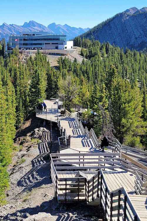
More like a stroll than a hike, the wooden pathway contains a lot of stairs that transverse the rugged peak. While the walk may appear easy, the high altitude can quickly contribute to breathlessness.
The path offers lots of benches and plaques to read about the terrain and wildlife. At the end of the trail, visitors can peer inside the old Cosmic Weather Station and marvel at the splendid views.
Tunnel Mountain
- Difficulty: Moderate | Distance: 4.5 km return
Located in the heart of Banff, Tunnel Mountain might be an ideal hike for those without a vehicle. From the top of Sulphur Mountain, Tunnel Mountain is easily recognizable as the hump behind the Fairmont Banff Springs Hotel.
While the mound may look ominous, the trail itself offers a steady incline all the way. At the peak, you’ll savor the magnificent views across Bow Valley, Bow River, the Banff Springs Golf Course, and the Fairmont Banff Springs Hotel.
Plan to spend 90 minutes to reach the summit.
While you can hike to Tunnel Mountain in winter, you’ll need snow shoes to tackle the climb. During the spring, expect a muddy route due to the melting snowpack.

Banff Hiking Tips
Parks Canada does a wonderful job of maintaining the trails in Banff and surrounding national parks. But, before you head out into the wilds of Banff, there are some fundamental rules of hikes you should know.
- Check on the trail conditions first.
- You’re in bear country. So, carry a bear bell and bear spray.
- Ideally, don’t hike alone. On some trails, you may be required to hike as a group.
- Carry out everything you take in, including toilet paper.
- Do not remove plants, rocks, fossils, antlers, etc.
- Stay on the trails and do not damage vegetation.
- Dress appropriately. Weather can change quickly in the mountains.
- Carry bottled water. Avoid the water from streams and lakes.
- Wear boots with ankle support. Flip-flops or sandals won’t cut it.
- Carry enough water for your hike. Drinking water from rivers or lakes is not recommended.
- Use a hiking pole.
Final Thoughts
There are few places that I traveled to globally that have left me speechless. But Banff National Park achieves that recognition. With over 1,500 kilometers of trails, Banff National Park provides trekkers with a multitude of options.
With a good pair of hiking boots and an adventurous spirit, I have enjoyed amazing hikes in Yoho National Park nearby. To the north, consider driving on the Icefields Parkway, as Jasper National Park has some great hikes too.
After one visit, you’ll understand why the Rockies are a bucket-list item. So, savor the scenery, enjoy the backcountry, take plenty of photos, and leave no trace.
Happy travels ~ Karen